The Sagala Trek, also known as the 'Haa Planters' Trail,' holds historical significance as it was the route used by rice planters from Haa to travel to Paro in ancient times to assist with rice cultivation.
Distance
Difficulty
Moderate
Best Months to Trek
The trek is best done during the spring (March-May) or fall (September-November) when the weather is mild and the trails are clear.
Description
What's Included
What's Excluded
-
 Mineral bottled water
-
 Government fee, royalty, taxes & surcharges
-
 Entry fees & road permits
-
 Visa for Bhutan
-
 Licensed English-speaking guide
-
 Accommodation at 3 star hotel
-
 Tour driver & vehicle
-
 Private tour guide
-
 Full service & assistance before, during and after your Bhutan trip
-
 Daily 3 meals (B/L/D) at designated restaurants or hotels
Checklist
- Sunglasses
- Winter hat and gloves
- Comfortable footwear
- Cap/hat
- Trekking shoes (Comfortable and waterproof)
- Water bottles of at least 3 litres total capacity
- Thermal wear
- Backpack with rain cover
- Hiking poles (to lessen the impact of walking on your joints)
- Waterproof jacket and pants
- Headlamp with extra batteries
-
 Airport transfers
Checklist
- Sunglasses
- Winter hat and gloves
- Comfortable footwear
- Cap/hat
- Trekking shoes (Comfortable and waterproof)
- Water bottles of at least 3 litres total capacity
- Thermal wear
- Backpack with rain cover
- Hiking poles (to lessen the impact of walking on your joints)
- Waterproof jacket and pants
- Headlamp with extra batteries
Accommodation and Meals
Like most of the trekking, the accommodation during the trek is mainly camping in tents. Bhutan does not have any commercial guesthouses along the trekking trail, as many of them are in remote areas and are in environmental regions that are protected from development.
All meals are included and prepared/catered by the cook and staff that will accompany you along the trail throughout the entire trekking period. On the trek you are assisted by your local guide, a cook, 2-3 helping staff/porters depending upon the group size.
Important Notes
Provided on the trek:
- Sleeping tent
- Dining tent
- Kitchen tent
- Toilet tent
- Inflatable air mats or mattresses
- Carpets
- Hot water bags
- Table and chairs
- Sleeping bag liners and blankets
- Duffle bags
Sagala Trek Itinerary
3 Days
Haa to Talung (3,000 meters) - Sagala (3,720 meters)
You will drive from Haa to Talung and the trek begins from Talung.
Today the distance to be covered is 9 Km which will take about 4-5 hours with an ascent of 480 m.
You‘ll begin your trek by walking gradually uphill through a blue pine forest and farmland. As you climb it gets a little steeper and you walk along streams past rhododendron, juniper, spruce, and birch trees.
Taking the trail on the right side of the village, you will climb up gradually through yak herders camp. We take the right trail to make your final climb towards your camp at Sagala.
Highlight
Sagala - Nyingungla/nigula (3,800 meters)
Today the distance to be covered is 7 Km which takes about 4-5 hours with an ascent of 950 m and descent of 250 m.
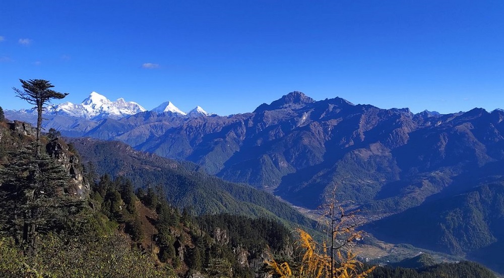
Begin climbing up to Sagala Pass (3550m), where in clear weather, you will have superb views of Mount Jumolhari (7,314m) and Jitchu Drake (6,989m).
From the pass, walk on the right side of the trail. After making several ascents and descents, walking through the trails of rhododendrons and meadows, you will finally be on the top of the ridge at 4100m, which offers great views of Haa Valley below.
Making occasional ascents and descents through forests of hemlock and juniper, you will reach your camp at 3800m.
Highlight
Nyingungla/nigula - Chele la Pass (3,756 meters), End of the trek
The distance today will be 10 km which will take about 6-7 hours with an ascent of 500 m and descent of 360 m.
Descending for a few minutes and following the ridge through meadows and yak herder’s camp, we climb uphill through the forest of tall rhododendrons toward Kung Karpo Sky Burial at 4350m.
The view of Haa Valley is spectacular as you climb up through these stone cairns to Kung Karpo. From the sky burial, you will be walking up and down with a panoramic view of Paro Valley on the left and Haa Valley on the right.
The view of Kila Goenpa Nunnery below is also spectacular. Walk further downhill until you reach Chelela Pass , which is one of the highest motorable passes in Bhutan.
Highlight
Trekking Map
